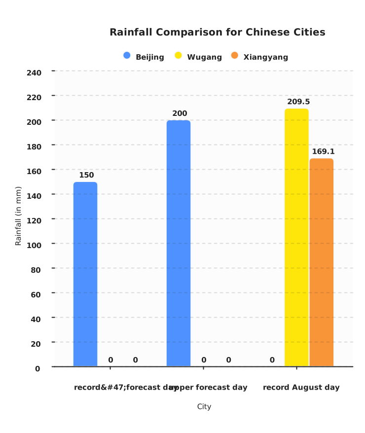
Typhoon Dolphin’s remnants inundated Beijing and central China on August 12, 2026, triggering thousands of evacuations and widespread transport shutdowns. Record daily rainfall totals—209.5 mm in Wugang and 169.1 mm in Xiangyang—broke August marks, while the capital faced more than 150 mm in a day, over a quarter of its annual average.
The disruption exposed the limits of China’s urban flood defences, despite heavy investment in sponge-city infrastructure. Final rainfall tallies are still being assessed, but the storm—the strongest to hit China this year—forced at least seven provinces to activate emergency measures.
China has spent heavily on sponge cities and flood barriers. On Wednesday, Beijing shut down. The remnants of Typhoon Dolphin dumped more than 150 millimeters of rain in less than a day—approximately one-quarter of the city’s average annual total—and forced thousands from their homes, while authorities suspended bus routes and reduced train speeds on ten metro lines.
The storm, the strongest to hit China in 2026, made landfall in Zhejiang on Sunday before weakening. Its moisture-laden remnants set a new August daily rainfall record in Wugang, Henan, at 209.5 millimeters. In Beijing, an orange rainstorm warning—the second-highest level—remained in place through Wednesday morning.
That a single system could still trigger mass evacuation and transport collapse in the capital suggests the adaptation gap is larger than the investment scale implies. The question now is whether the city’s defence can absorb what is still falling.
A capital caught between its defences and the rain
Wugang, a city in Henan, received 209.5 millimeters of rain in a single day, breaking its all-time August record. Typhoon Dolphin had already been the strongest storm to hit China this year when it made landfall on Sunday, August 11; its remnants kept moving inland.
Xiangyang in Hubei set its own August mark at 169.1 millimeters. Beijing’s meteorological service said most of the city would receive over 150 millimeters in 24 hours, with some districts possibly exceeding 200 millimeters—close to 40 percent of the city’s average annual precipitation. The numbers from Wugang, Xiangyang, and the Beijing forecast describe a single moisture plume moving north.
By Wednesday morning, Beijing had suspended 250 bus routes and slowed trains on 10 metro lines. Multiple districts on the city’s outskirts activated high‑level emergency flood response protocols.
More than 1,300 tourists were evacuated or turned away from hundreds of closed attractions and campsites.
Over 5,000 elderly residents were moved from care facilities.
About 1,800 construction‑site dwellers were relocated.
For a Beijing resident roused before dawn to leave a suburb where landslide risk had reached critical thresholds, the statistic mattered less than the order to move. In Hebei, authorities dispatched 623 emergency teams and equipped more than 2,100 villages with satellite phones or messaging terminals. Henan sounded a red alert—the highest level—and suspended schools and businesses as forecasts reached 350 millimeters.
Wang Xiaoling, deputy director of Hubei’s provincial meteorological observatory, said peripheral airflow rising over mountains would cause rainfall to intensify several times over. Wang Haiping, chief forecaster at the National Meteorological Centre, warned that Dolphin’s slow inland track would prolong the flood and landslide risk. The immediate cost fell on residents, tourists, and construction crews forced to leave, and on emergency crews dispatched to guard rivers and slopes.
Until the China Meteorological Administration releases final rainfall totals and any damage assessments, the full picture of whether drainage upgrades held and how many areas flooded remains provisional. State media reported the closures and rescues; independent verification is scarce.
Such widespread disruption, even with an early warning system that activated on schedule, raises a structural question: whether a tiered emergency response can outpace rainfall that arrives faster than the design assumptions behind it.
A system built for incremental risk faces a step change
China’s flood-control framework operates through a four‑tier system—Level I the most severe, Level IV the lowest—managed by the Ministry of Water Resources and provincial authorities. In early August, the ministry activated Level IV responses in multiple provinces as rainfall forecasts widened, emphasising monitoring, reservoir safety checks, and patrols for flash‑flood and dam‑breach risks. The architecture is designed around early warning and local escalation, not a single national lockdown.
Yet the same framework that dispatched warning teams could not prevent Beijing’s mass evacuation and shutdown. The gap is visible: an operational system built to react faster still cannot absorb rainfall that arrives as a sudden, record‑breaking pulse. Sponge‑city projects aim to capture 70% of the water on‑site, but construction remains incomplete and uneven across the capital’s districts.
Climate scientists link the rising intensity to warming oceans and an El Niño cycle that amplifies Pacific storm activity. That connection means the baseline against which the tiered alerts are calibrated is slipping. The next question is whether the levels themselves—still informed by past averages—can accommodate rainfall that rewrites the record books every few years.
Beyond the headline
The Bigger Picture
This is not just a storm story; it is a stress test for China’s flood-management model. The key issue is that the country’s disaster system is increasingly being asked to manage rainfall patterns that arrive faster, fall harder, and move farther inland than the older design assumptions behind urban drainage and provincial flood planning.
The Science Gap
The scientific problem is no longer whether climate change can intensify extreme rainfall, but how quickly forecasting and emergency systems can translate that knowledge into action. The coverage points to stronger typhoons and El Niño amplification, yet the operational gap is whether those warnings change evacuation timing, transport rules, and protection of exposed districts before damage begins.
The Response Gap
China’s response apparatus is broad, but it is still weighted toward last‑minute alerts, closures, and evacuations rather than durable flood avoidance. That matters because a capital city that can suspend buses and move residents quickly still remains vulnerable if drainage, slope protection, and reserve capacity cannot absorb the peak rainfall itself.
What Beijing’s shutdown means for supply chains, safety, and urban investment
With transport still disrupted and rainfall totals set to mount, immediate decisions face four groups with China exposure.
- Western business operator with supply chain links in China
Assess whether your logistics routes pass through Hebei, Henan, or Hubei corridors hit by road and rail delays. Communicate with local partners to determine restoral timelines, and activate contingency plans for manufacturing or distribution interruptions. Check the China Meteorological Administration for rainfall updates and provincial transport notices within the next 24 hours.
- Western expat or student currently in Beijing or central China
Monitor local emergency alerts and follow official evacuation orders. Public transport remains suspended on many routes; confirm restoration timing through Beijing municipal flood‑control notices. Keep a charge on communication devices and avoid travel through flood‑prone underpasses until water recedes.
- ESG investor with exposure to Chinese infrastructure or urban development
Re‑evaluate the climate risk assessments of portfolio companies involved in urban infrastructure, especially those with exposure to the Beijing‑Tianjin‑Hebei corridor. Ask whether their current adaptation assumptions account for single‑day rainfall pulses that exceed design thresholds, and demand transparent disclosure of how physical climate risks are modeled.
- Policy professional focused on climate adaptation in urban environments
Analyze the specifics of Beijing’s response—the gap between early warning activation and the need for mass evacuation—to inform recommendations for other global cities. The case suggests that even well‑funded, tiered response systems can be overwhelmed when rainfall intensity accelerates ahead of infrastructure renewal cycles.
Explainer
- Sponge city
- A Chinese urban design strategy that uses permeable surfaces, rain gardens, and wetlands to absorb and reuse stormwater. Beijing’s plan aims to manage 70% of annual rainfall on-site, reducing strain on drainage. Implementation remains incomplete across many districts, which limits its effectiveness during extreme events like Typhoon Dolphin.
- Orange rainstorm warning
- The second-highest level in China’s four-tier rainstorm alert system, issued when rainfall is expected to exceed 50 millimeters in 6 hours or 100 millimeters in 12 hours. It triggers closure of outdoor attractions and suspension of public activities. Beijing remained under an orange warning through Wednesday morning.
- Red alert
- China’s highest rainstorm warning, requiring schools and businesses to close and all outdoor activities to cease. It is triggered when forecast rainfall exceeds 250 millimeters in 24 hours. Henan province declared a red alert on August 12 as forecasts reached 350 millimeters.
- El Niño
- A climate pattern caused by periodic warming of the central Pacific Ocean, occurring every two to seven years. It typically strengthens typhoon activity in the western Pacific by raising sea surface temperatures and altering atmospheric circulation. The current El Niño cycle has been linked to the exceptional intensity of Typhoon Dolphin.
RELATED STORIES