China is accelerating the China-Myanmar-Bangladesh Economic Corridor as its western overland routes face mounting disruption from insurgency, sanctions, and geopolitical friction. The pivot has triggered India’s National Maritime Security Strategy 2026, which identifies the Bay of Bengal as an arena of long-term competition shaped by ports, logistics networks, and infrastructure control rather than naval balances alone.
The shift turns the Bay of Bengal into a contest over who designs the region’s infrastructure map. India’s response centres on Great Nicobar, the Sabang port partnership with Indonesia, and deeper defence ties with the US, Japan, and Australia — a strategy calibrated to a geography now being redrawn.
The western corridors were always vulnerable. The China-Pakistan Economic Corridor has been bleeding reliability for years — Baloch insurgents targeting Chinese nationals, Tehrik-i-Taliban Pakistan expanding its reach, and the Afghanistan-Pakistan borderlands destabilising faster than Beijing can secure them. The Iran route, through Chahbahar and Zahedan, now carries the added weight of US-Iran conflict, sanctions, and insurance costs that make long-term planning impossible. Even the Middle Corridor through Eurasia remains exposed to capacity constraints and political uncertainty across multiple transit states.
None of these routes has failed. Each has simply become unreliable enough that Beijing can no longer treat them as assured access to the Indian Ocean. The strategic premium on China’s eastern gateway — through Myanmar to the Bay of Bengal — has risen accordingly. And India has noticed.
A corridor becomes a contest
From May 30 to June 3, 2026, India’s prime minister hosted Myanmar’s newly-elected President in New Delhi with a specific agenda: accelerate the Kaladan Multi-Modal Transit Transport Project and the India-Myanmar-Thailand Trilateral Highway. The visit was not about diplomacy in the abstract. It was a connectivity countermove, aimed at matching China’s infrastructure reach into the same geography Beijing is now prioritising.
China’s answer is the China-Myanmar-Bangladesh Economic Corridor, a framework that extends beyond the troubled Kyaukphyu port in Myanmar’s Rakhine state. By adding Chattogram and potentially Mongla in Bangladesh, Beijing is building a distributed logistics architecture across the northern Bay of Bengal — one that reduces dependence on any single node and broadens its commercial footprint in the process.
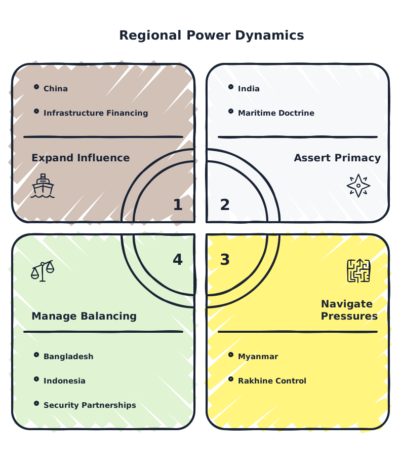
The web of interests connecting these five actors is easier seen than read.
India has sanctioned approximately $3.22 billion to fence and patrol its 1,643-kilometre border with Myanmar, a project that links border security directly to the corridor competition. Unresolved demarcation around border pillars 65 through 68 in Manipur’s Chandel district complicates the effort, but the intent is clear: secure the eastern flank before Chinese-linked infrastructure hardens the geography.
| Entity | Current rule | New rule | Effective date |
|---|---|---|---|
| China | Reliance on CPEC and western corridors for Indian Ocean access | Distributed Bay of Bengal network via Myanmar and Bangladesh | Accelerating through 2026 |
| India | Continental defence posture with limited eastern maritime focus | INMSS-2026 doctrine prioritising Great Nicobar, Sabang, and maritime partnerships | April 2026 |
| Myanmar | Bilateral infrastructure deals with China under CMEC | Extended corridor framework incorporating Bangladesh; contingent on civil war dynamics | Under negotiation |
| Bangladesh | Hedging between Chinese investment and Indian sensitivities | Potential deep port integration with Chinese corridor; border fortification against Myanmar spillover | Decision expected within 6–12 months |
| Indonesia | Non-aligned maritime posture | Major Defense Cooperation Partnership with US; expanded defence ties with Japan and Australia around Malacca | Ongoing |
| Source: Indian Ministry of External Affairs; US Department of Defense; analysis of corridor frameworks | |||
External Affairs Minister S. Jaishankar has argued that connectivity today is about trust, resilience, and strategic autonomy, positioning India’s East Coast ports and economic corridors as security assets rather than purely commercial ventures. The framing is not rhetorical. It is the intellectual foundation of INMSS-2026, which argues that economic corridors, commercial ports, and dual-use facilities are now integral components of maritime power.
The pattern that made this predictable
China’s eastern pivot was visible years before INMSS-2026 named it. The Strait of Hormuz handles nearly one-fifth of global oil consumption, and recent shipping data already show tanker movements slowing under the weight of Iran-US tensions. A 30-day disruption would significantly raise India’s import bill and global energy costs. For Beijing, the lesson is not new: a single chokepoint is a single point of failure.
The Kyaukphyu pipelines already offer an alternative energy route into Yunnan province. The planned road and rail links promise to strengthen commercial connectivity over time. But civil conflict in Rakhine and Shan states constrains every timeline. Just as insurgency has imposed growing costs on CPEC, Myanmar’s fragmented security environment limits the predictability of China’s corridor. The Bangladesh extension is, in part, an insurance policy against that unpredictability.
Bangladesh is fortifying its own position. A planned barbed-wire fence along 108 kilometres of the Myanmar frontier targets high-risk stretches where more than 426 Bangladeshi fishermen have been detained or abducted since late 2024. Retired Major General Mohammad Shahidul Haque, a former Bangladeshi defence adviser in Myanmar, argues the fence alone cannot resolve cross-border insecurity — it requires parallel investment in patrol roads and surveillance. The fence is a signal, not a solution.
Two near-term decisions will shape the next phase. Dhaka’s choice on whether to formalise large-scale Chinese investment packages at Chattogram and Mongla — expected within 6 to 12 months — will signal the depth of Bangladesh’s integration into the corridor. India’s internal clearances and tender awards for Great Nicobar‘s transshipment port will show whether fiscal and ecological constraints delay its maritime pivot or allow timelines that match China’s acceleration. The contest is no longer about who announces a project. It is about who finishes one.
Beyond the headline
The Bigger Picture
The Bay of Bengal is becoming the hinge between India’s continental anxieties and China’s search for maritime resilience. What began as discrete port investments now resembles a contest over who designs the region’s infrastructure map, from energy pipelines to data cables. That shift turns economic corridors into long-term instruments of influence, where control over logistics and standards could matter as much as carrier groups or missile ranges.
The Power Behind It
Formal governments are not the only actors shaping this contest: militaries, insurgent groups and security bureaucracies are quietly defining what is feasible on the ground. India’s border-fencing drive and Myanmar’s fragmented command structures determine how secure any corridor really is, while Indonesia’s defence establishment now acts as a gatekeeper around Malacca. The balance of power is thus being set as much by who can manage instability as by who can pour concrete.
The Reach
For Western actors, the most consequential lever lies with Indonesia’s choice to deepen defence cooperation with the US, Japan and Australia. That single network influences surveillance, access and crisis-response around Malacca far beyond the Bay of Bengal itself. If Jakarta continues opening its maritime domain to joint monitoring and exercises, Western navies gain a stabilising presence at the doorway to the Indian Ocean, cushioning shocks from any Sino-Indian confrontation downstream.
The decisions that will define the next phase
With China’s corridor acceleration and India’s maritime strategy now locked into competing timelines, four groups face distinct calculations.
- Western maritime logistics and insurance executive
You need to reassess risk models for vessels transiting the Bay of Bengal and Malacca. Monitor the US Department of Defense news releases for joint exercise announcements involving Indonesia — these signal the operational tempo around the chokepoint. Adjust war-risk clauses and contingency routing for cargo that depends on Chattogram, Mongla, or Kyaukphyu calls.
- US defense and foreign policy analyst focused on Indo-Pacific
The Major Defense Cooperation Partnership with Indonesia is the most underappreciated lever in this contest. Track its evolution through US-Indonesia joint statements and force-posture announcements. The partnership’s value lies less in formal alliance structures than in the access it provides for maritime domain awareness near Malacca and the Six Degree Channel.
- European energy trader with APAC exposure
Hormuz disruption data already shows tanker movements slowing. A parallel disruption near Malacca — even a brief one — would compound price effects. Monitor Indian government port announcements through the Ministry of Ports, Shipping and Waterways for Great Nicobar tender awards; these signal how quickly India can offer a stabilising logistics presence along the route your cargoes depend on.
- Western infrastructure investor eyeing South Asia
Bangladesh’s decision on Chinese port investment packages at Chattogram and Mongla — expected within 6 to 12 months — is your signal. A long-term lease or operating-rights deal means Dhaka is leaning into the corridor. Without it, expect continued hedging and smaller-scale projects. Either outcome shapes the risk profile of any infrastructure exposure in the northern Bay of Bengal.
Explainer
- INMSS-2026
- India’s National Maritime Security Strategy 2026, released in April 2026, is New Delhi’s foundational doctrine for maritime competition. It identifies the eastern Indian Ocean and Bay of Bengal as arenas of long-term strategic contestation shaped by ports, logistics networks, and dual-use infrastructure. The strategy marks a shift from viewing maritime power in purely naval terms to treating economic corridors and commercial ports as integral components of national security.
- Kyaukphyu
- A deep-water port in Myanmar’s Rakhine state, Kyaukphyu is the centrepiece of the China-Myanmar Economic Corridor and the terminus of existing oil and gas pipelines to Yunnan province. It offers China a direct Bay of Bengal outlet that bypasses the Strait of Malacca. Civil conflict in Rakhine and Shan states continues to threaten the security of transport routes leading to the port.
- Great Nicobar
- India’s southernmost territory, located near the northern entrance to the Strait of Malacca and the Six Degree Channel. A planned transshipment port and dual-use infrastructure project aims to transform the island into a hub for logistics, surveillance, and maritime operations. Its strategic value lies in its position astride one of the principal maritime gateways connecting the Pacific and Indian Oceans.
- Sabang
- A port on Indonesia’s Weh Island, situated near the northern entrance to the Strait of Malacca. India and Indonesia have agreed to develop Sabang as a maritime hub, complementing India’s Great Nicobar project. Indonesia’s expanding defence partnerships with the US, Japan, and Australia have turned Sabang and its adjacent waters into a monitored zone between Indian and Chinese naval operating areas.
- Six Degree Channel
- The narrow maritime passage between Great Nicobar and Indonesia’s Sumatra, forming one of the principal gateways between the Pacific and Indian Oceans. It sits adjacent to the Strait of Malacca and handles a significant share of global maritime trade. Control over surveillance and domain awareness in the channel directly affects the security of energy and commercial shipping flows between East Asia and the Indian Ocean.
RELATED STORIES